Berger´s
Homepage
© Anton Berger, 1998
Hveravellir
All information presented within this webpage
is taken from the small booklet "HVERAVELLIR" you get from Ferðafélag
Íslands during your stay at Hveravellir. Ask the warden in the mountain
hut!
Feel free to contact me for further information or
feedback!
Thanks for dropping in. |
|
| HVERAVELLIR - Stopover in the mountains |
 |
Figures give estimated walking time to the location and back again from
Hveravellir or other points as indicated.
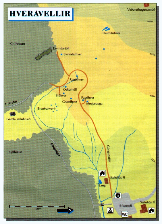
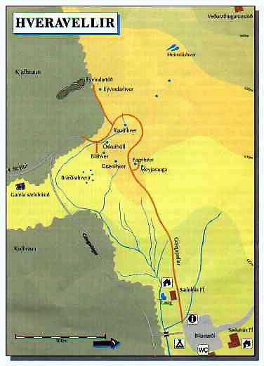 HOT SPRING AREA
From platforms set up to protect the hot spring area near the older mountain
hut of the Touring Club of Iceland, FÍ., the way leads to a refuge
identified with an outlaw from former times (Eyvindartóft) and a shelter
along the edge of the lava field. 15-30 min.
EYVINDARHELLIR AND EYVINDARRÉTT
Follows markers past the shelter to a small cave in a lava mound called
Eyvindur's cave (Eyvindarhellir). Farther on, a rift in a lava, blocked with
fitted stones is called Eyvindur's sheep pen (Eyvindarrétt). 30-45
min.
STRÝTUR
The row of peaks called Strýtur forms part of the rim of a large crater
840 m above sea level. The path from Hveravellir is marked. 3-4 hrs.
DÚFUNEFSFELL
730 m peak NE of Hveravellir offering a fine view. The Icelandic medieval
Book of Settlements tells of a legendary horse race won by Þórir
dúfunef (Dove-nose) on the flat plain Dúfunefsskeið south
of the mountain. 30-min. walk from Kjölur trail or 3-4 hrs. from
Hveravellir.
STÉLBRATTUR-þJÓFADALIR MOUNTAINS
Follows the tributaries of the stream þegjandi north of the mountain
StéIbrattur toward the peak Oddnýjarhnjúkur in the
þjófadalir mountains, 1067 m above s.l. 6-8 hrs. or 3-4 hrs.
if only circling StéIbrattur.
þJÓFADALIR-RAUÐKOLLUR
High up in þjófadalir is a mountain track passable for all-terrain
vehicles by late summer. Please note that to prevent damage to vegetation
all driving into the valleys themselves is prohibited. Several hiking trails
lead out of þjófadalir, e.g. up to the ridge of þverfell
and onto Rauðkollur, 1075 m. From Rauðkollur one can head back NE
following the ridge of the mountain.
RJÚPNAFELL AND GRETTISHELLIR
Along the former Kjölur trail, about 2 km south of Rjúpnafell.
under a large hill of lava topped by numerous cairns, is a cave called
Grettishellir. 5-7 hrs.
BEINAHÓLL
The monument commemorates the ill-fated expedition of the brothers from
Reynistaður in Skagafjörður who died in a snowstorm here in
1780. The name Beinahóll (Bone hill) is said to refer to the remains
of sheep and their horses. Please take care not to disturb any bones or remains.
To reach the site drive along the marked track which begins south o
Fjórðungsalda (Geirsalda where the viewpoint marker is) until
it ends, then wall the short distance remaining. To return, follow the same
route or walk the trail northward marked by cairns which passes Grettishellir,
then turn off the trail to reach Hveravellir. 4-5 hrs. 2 hrs. if walking
back.
HIKING TRAIL FROM HVÍTÁRNES TO HVERAVELLIR
 Have a look to the more detailed maps of
Hveravellir and
Kjölur !
Have a look to the more detailed maps of
Hveravellir and
Kjölur !
The trail from Hvítárnes to Hveravellir follows much of the
former Kjölur trail. Starting from the FÍ mountain hut at
Hvítárnes (accommodates 30). the first leg to
þverbrekknamúli (accom. 20), takes 4-5 hrs. The next leg, into
þjófadalir (accom. 12), takes 4-5 hrs. and the final stretch
to Hveravellir 3-4 hrs.
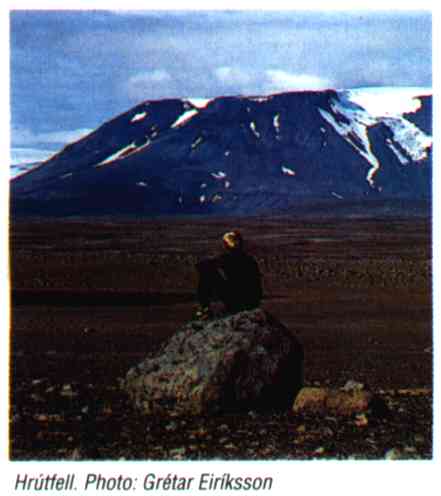
HVERAVELLIR (HOT-SPRING PLAINS)
The highland region between the glaciers Langjökull and Hofsjökull
is called Kjölur (The Keel). The landscape in the region has been shaped
by the glacier of the last Ice Age, which receded some 10 thousand years
ago. Table mountains, stapar such as Hrútfell, of tuff were
formed in eruptions under glacial caps. The shield volcano, or dyngja;
Kjalhraun was formed by thinly flowing lava soon after the glaciers
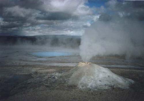
receded. In a hollow near its northern end is the Hveravellir high-temperature
area (over 150 degrees C 1000 m underground), 630 m above s.l.
The oldest written description of the area, from 1752, describes the hot
springs, from one of which (named Öskurhóll or Shrieking mound)
rumbling and whistling noises issued forth. The water in the hot springs
contains large amounts of dissolved substances and as it rises to the surface
it cools and various substances are deposited to form crusts around the springs.
The unusually colourful crusts formations at Hveravellir are mainly of silica.
There is no great variety of animal life in the area. Sheep graze here in
the summer and fence prevents them from crossing between districts and thus
inhibits the spread of sheep diseases. Arctic foxes make their homes here,
in autumn ptarmigans can be seen and geese have been growing in number in
recent years. The moorland waterfowl here are similar to those elsewhere
in the highlands of Iceland.
 Vegetation at Hveravellir is characterized by
the short growing season, snowbed plants, like Creeping Sibbaldia and Dwarf
Cudweed, are common, along with a number of other species such as Alpine
Lady´s-mantle, Common Cottongrass and Marsh Arrowgrass. In an older
hot spring area south of the stream is considerable warm ground and this
affects the vegetation. To the north and west patches of thriving Iceland
moss can be found.
Vegetation at Hveravellir is characterized by
the short growing season, snowbed plants, like Creeping Sibbaldia and Dwarf
Cudweed, are common, along with a number of other species such as Alpine
Lady´s-mantle, Common Cottongrass and Marsh Arrowgrass. In an older
hot spring area south of the stream is considerable warm ground and this
affects the vegetation. To the north and west patches of thriving Iceland
moss can be found.
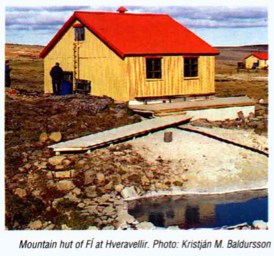
Ferðafélag Íslands (FÍ) built a mountain hut here
in 1938 and another in 1980. The year-round weather station at Hveravellir
was built nearby on the plain Breiðamel in 1965.
KJALVEGUR - THE KJÖLUR TRAIL
 The shortest route between North and South Iceland lies over
the Kjölur highlands. During the first centuries of Icelandic settlement
the route was an important and much-frequented trail. The Book of Settlements
relates that the first exploratory journeys over Kjölur were made around
or just before the turn of the tenth century, and refers to Hveravellir as
Reykjavellir (Smoky plains). In the 17th century, however, traffic along
the Kjölur route diminished. One reason for this was the decreasing
numbers attending the annual Assembly, the Althing, at þingvellir,
which was disbanded just before 1800, so that fewer travellers had reason
to cross the highlands. In addition, the grim fate of the Reynistaður
brothers did much to increase fear and deter men from using the route.
The shortest route between North and South Iceland lies over
the Kjölur highlands. During the first centuries of Icelandic settlement
the route was an important and much-frequented trail. The Book of Settlements
relates that the first exploratory journeys over Kjölur were made around
or just before the turn of the tenth century, and refers to Hveravellir as
Reykjavellir (Smoky plains). In the 17th century, however, traffic along
the Kjölur route diminished. One reason for this was the decreasing
numbers attending the annual Assembly, the Althing, at þingvellir,
which was disbanded just before 1800, so that fewer travellers had reason
to cross the highlands. In addition, the grim fate of the Reynistaður
brothers did much to increase fear and deter men from using the route.
Danish surveyor Daniel Bruun travelled the route near the end of the 19th
century and urged that the Kjölur route be marked with stone cairns.
All the rivers along the route are bridged but the trail is passable to vehicles
only in summer.
FJALLA-EYVINDUR AND HALLA
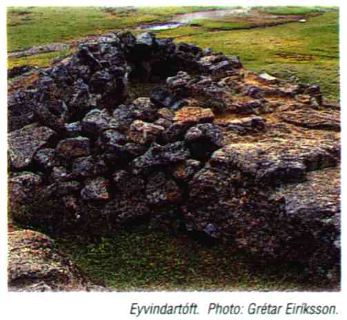 The most famous of all Icelandic outlaws, folk who fled the
law to live in hiding in the remote highlands, were the couple Fjalla-Eyvindur
(Mountain Eyvindur) and Halla.
The most famous of all Icelandic outlaws, folk who fled the
law to live in hiding in the remote highlands, were the couple Fjalla-Eyvindur
(Mountain Eyvindur) and Halla.
They reportedly fled into the highlands shortly after 1760 and spent some
20 years living in the wilderness. At Hveravellir, as in many other areas
of the highlands, numerous place names recall their stay. On the ridge west
of the hot spring area is Eyvindur's refuge, considered to be the remains
of a hovel in which they dwelt.
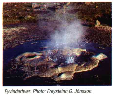
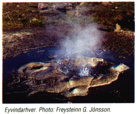
A nearby hot spring named Eyvindarhver has a fitted wall of stones around
it to facilitate the boiling of meat.
TRAVELLING THROUGH AND STAYING AT HVERAVELLIR
 Because of the unique hot spring area, Hveravellir was declared
a nature preserve in 1960 in accordance with the laws on natural conservation.
The Iceland Nature Conservation Council has jurisdiction over the area but
FÍ is permitted to maintain its mountain huts.
Because of the unique hot spring area, Hveravellir was declared
a nature preserve in 1960 in accordance with the laws on natural conservation.
The Iceland Nature Conservation Council has jurisdiction over the area but
FÍ is permitted to maintain its mountain huts.
Hveravellir is a highly suitable location for travellers to pause in their
journey. The mountain huts, heated with hot spring water, can accommodate
70 persons. South of the older mountain hut there is a small hot pool (visitors
may not use the hut as a changing room). There are toilets here and washbasins
at the camping area.
FOLLOW THE VISITOR RULES!
Visitors in the mountain huts and campground are to refrain from disturbing
others from 11 pm to 7 am. Exercise caution in the hot spring area, keep
to the platforms. The water is from 70-100 degrees C so children must be
kept under constant observation, even near hot springs which are not boiling.
All damage to the natural environment is prohibited. Treat the geological
formations and vegetation with care, and refrain from building cairns, breaking
off pieces of the hot spring crusts or altering their appearance in any way.
Do not throw rocks, turf or other objects into the hot springs, they will
become blocked. Camping is only permitted in the campground area.
Do not drive off-road. Take refuse back with you, or put it into refuse
containers. Bathers are reminded not to take soap or glass containers along
to the pool.
WINTER TRAVEL
An increasing number of travellers head for Hveravellir during winter months.
As the weather can quickly worsen in the highlands, travellers should always
be well outfitted and notify others of their journey. All traffic is prohibited
in spring once the snows begin to melt until the highland tracks re-open
for summer traffic. Maps indicating the openings are printed each spring.
INFORMATION
The wardens of the Iceland Nature Conservation Council and FÍ are
on the job at Hveravellir from the time the mountain tracks open in late
June -early July until the end of August. They look after the campground
and mountain huts, provide information, and make sure rules are complied
with. Weather station attendants look after the mountain huts during the
winter months. Reserve mountain hut accommodation in advance at the Touring
Club office. Tel. 568 2533 (85 41193).
Náttúruverndarráð, Hlemmi 3, 105 Reykavík
Ferðafélag Íslands, Mörkinni 6, 108 Reykjavík
All information presented within this webpage
are taken from the small booklet "HVERAVELLIR" you get from
Ferðafélag Íslands during your stay at Hveravellir. Ask
the warden in the mountain hut! Also these photo´s were scanned from
this booklet.
High resolution photos:
Low resolution photos:


